Close Encounter with a Gigantic Jet

Oct. 25, 2019: When you see lightning, run! That’s what NOAA advises in lightning safety brochures. On Oct. 15th, however, pilot Chris Holmes had no place to go when lightning started to crackle in thunderstorms around his aircraft.

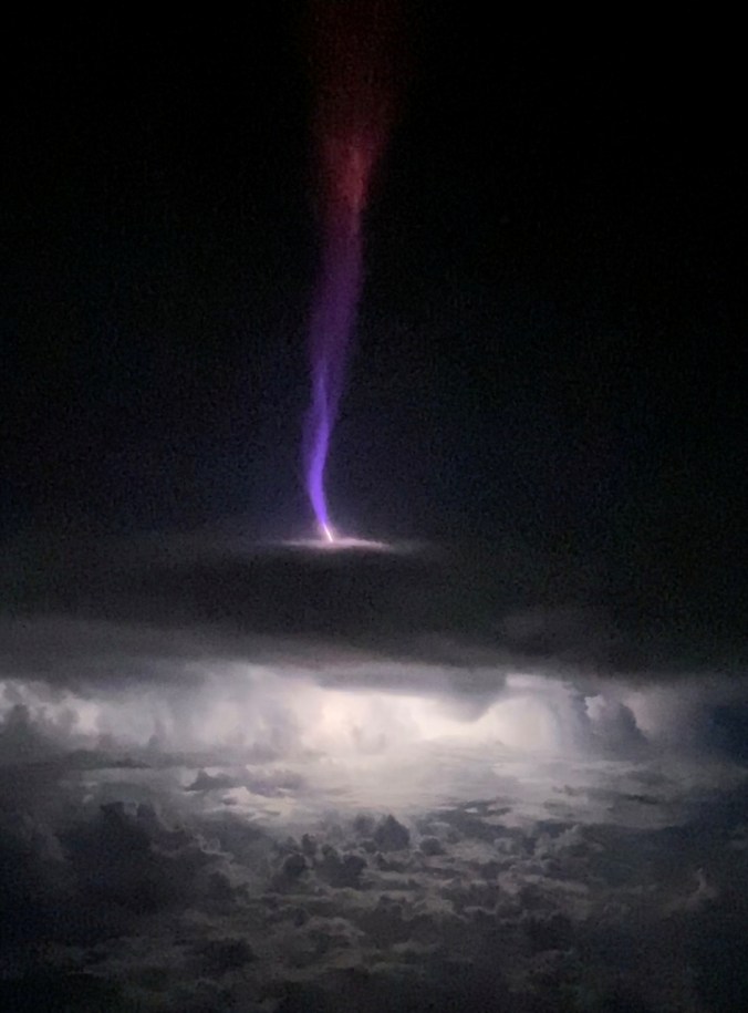
“I was flying 35,000 feet over the Gulf of Mexico near the Yucatan Peninsula when a super cell started pulsing with light,” he says. “It wasn’t just ordinary lightning, though. The cell was also creating lots of sprites and jets leaping up from the thunderhead.”

At a distance of only 35 miles, he video-recorded this:

gj_crop

“It was the most amazing thing I’ve seen in my aviation career,” he says.

Holmes had a close encounter with a Gigantic Jet. Sometimes called “Earth’s tallest lightning,” because they reach all the way to the ionosphere ~50 miles high, the towering forms were discovered near Taiwan and Puerto Rico in 2001-2002. Since then, only dozens of Gigantic Jets have been photographed. In previous images taken by cameras on the ground, it’s almost always impossible to see the base of the jet over the edge of the thundercloud. That’s why Holmes’s video is special. He was filming above the storm at practically point-blank range.

“His clip shows very nicely the top of the cloud where the jet emerges, which is usually hidden from view,” says Oscar van der Velde of the Lightning Research Group at the Universitat Politècnica de Catalunya who examined the footage. “I split the video into individual frames so we can see exactly what happens.”

panel_crop

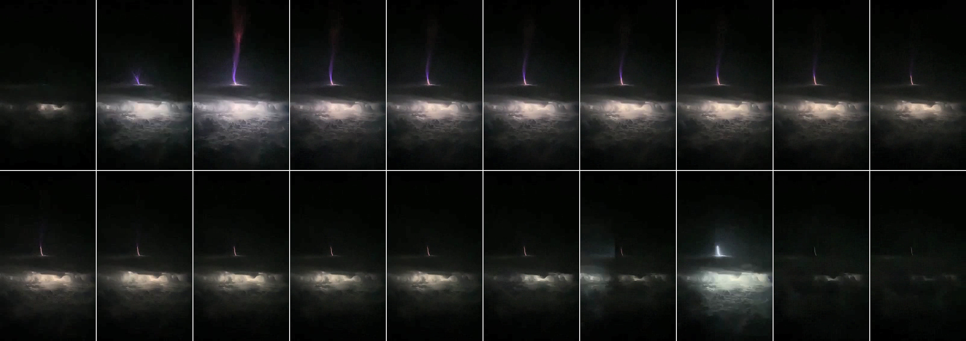
Van der Velde’s deconstruction reveals the order of events: “First, relatively cool blue filaments spring up. These are streamers akin to Saint Elmo’s Fire,” he explains. “Next, after the Jet reaches its maximum height, another feature crawls more slowly out of the cloudtop–a white-hot ‘lightning leader.'”

Turns out, this is a bit of a surprise. For years, some researchers thought that Gigantic Jets could reach such extreme heights only if their streamers got a boost from the lightning leader. Holmes’s video shows just the opposite: The Gigantic Jet reaches the ionosphere before the lightning leader even leaves the cloud.

“This suggests that there may be a much more powerful electric configuration inside the thunderstorm than was previously thought–perhaps as much as 200 million volts,” he says.

It just goes to show, we still have a lot to learn about Gigantic Jets.

This story was brought to you by Spaceweather.com

Cosmic Rays are Nearing a Space Age Maximum

Oct. 3, 2019: Solar Minimum is underway, and it’s a deep one. Sunspot counts suggest it is one of the deepest minima of the past century. The sun’s magnetic field has become weak, allowing extra cosmic rays into the solar system. Neutron monitors at the Sodankyla Geophysical Observatory in Oulu, Finland, show that cosmic rays are percentage points away from a Space Age record:

crinfo2

Researchers at the Sodankyla Geophysical Observatory have been monitoring cosmic rays since 1964. When cosmic rays hit Earth’s atmosphere, they produce a spray of secondary particles that rain down on Earth’s surface. Among these particles are neutrons. Detectors in Oulu count neutrons as a proxy for cosmic rays.

As the top panel shows, cosmic rays naturally wax and wane with the 11-year solar cycle. During Solar Maximum cosmic rays are weak; during Solar Minimum they are strong. The Space Age record for cosmic rays was set in late 2009-early 2010 near the end of a very deep Solar Minimum.

Records, they say, are meant to be broken. As 2019 comes to a close, neutron counts at Oulu are approaching the very high levels seen in 2009-2010. A new record could be just weeks or months away. This is important because excess cosmic rays pose a health hazard to astronauts and polar air travelers, affect the electro-chemistry of Earth’s upper atmosphere, and may help trigger lightning.

screenshot2

Because cosmic rays are such an important form of space weather, we’ve added a new data feed to our web site. It’s right here. Every day you can see how Oulu neutron counts are changing. The values are expressed as percentages of the “Space Age average”–that is, the average of all neutron counts since 1964.

This data feed is made possible by the extraordinary dedication and decades-long monitoring program of the Sodankyla Geophysical Observatory in Oulu, Finland. Thank you!

A “STEVE Storm” Hit Scandinavia

Oct. 2, 2019: When a stream of solar wind hit Earth’s magnetic field last Friday, Sept. 27th, forecasters expected an aurora storm around the Arctic Circle. Turns out, it was more of a “STEVE storm.” Many sky watchers in Scandinavia saw the mauve ribbon of light for the very first time. Göran Strand photographed the event from Handöl, Sweden:

“I finally got to see STEVE,” says Strand, who is a veteran observer of auroras, but had never seen STEVE before. “It all started when I noticed a faint green corona outside our mountain cabin. I grabbed my camera gear and headed out into the night. At my first stop along this road I encountered STEVE.”

STEVE (Strong Thermal Emission Velocity Enhancement) looks like an aurora, but it is not. The phenomenon is caused by hot (3000°C) ribbons of gas flowing through Earth’s magnetosphere at speeds exceeding 6 km/s (13,000 mph). These ribbons appear during some geomagnetic storms, revealing themselves by their soft purple/mauve glow.

STEVE normally appears at latitudes around +50N to +55N, on rare occasions dipping down into the +40s. In this case, however, the sightings were at unusually high latitudes, topping +60N in Handöl, Sweden (+63.3N); Ruovesi, Finland (+62.0N); Turku, Finland (+60.5N) and, if we round up a little, Laguja, Estonia (+58.2N). This event shows that the habitat of STEVE may reach farther north than previously thought. Aurora alerts: SMS Text.

Realtime STEVE Photo Gallery
Free:
Spaceweather.com Newsletter